Marine Surveys
📡 Marine & Terrestrial Survey Services
Precision data for sustainable coastal development and environmental resilience.
🧭 Accurate Data, Smarter Decisions
At OceanVolts, we deliver high-precision marine and terrestrial surveys using the latest technologies to assess coastal, oceanographic, and environmental conditions. Our survey insights power shoreline protection, infrastructure development, and regulatory compliance, ensuring sustainable, data-informed coastal management.
🌊 Our Marine Survey Capabilities
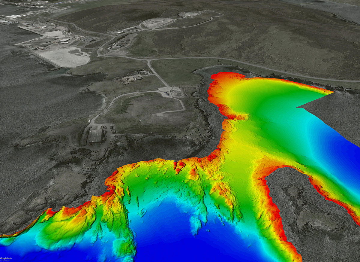
🗺️ Multibeam Bathymetry (Nearshore & Offshore)
High-resolution 3D seafloor mapping for depth profiles, morphology, and habitat features.
📡 Sub-Bottom Profiling
Detailed analysis of sediment layers and subsurface geology for marine construction planning.
🌊 Oceanographic Data Collection
Real-time measurement of wave height, currents, and tidal patterns for hydrodynamic modelling.
🐠 Reef & Coral Health Surveys
Scientific assessments of coral species, resilience, and biodiversity for restoration projects.
🧬 Bio-Morphological Coastal Surveys
Mapping of seabed changes, ecosystem structure, and coastal-marine interactions.
🏖️ Sediment Budget Analysis
Calculation of sediment transport, deposition zones, and erosion risk areas.
🌿 Wetland & Coastal Vegetation Surveys
Ecological mapping of mangroves, seagrasses, and wetlands for environmental conservation.
📏 Beach Profiling
Monitoring shoreline position, slope, and accretion/erosion trends over time.
🌬️ Sand Dune Mapping
Assessment of dune stability, movement patterns, and protective efficiency.
🌍 Terrestrial Survey Solutions
🗻 Topographic Surveys
Elevation and terrain mapping for construction, zoning, and coastal development.
🧱 Geotechnical Investigations
Soil structure and load-bearing analysis for foundations and slope stability.
🌧️ Land Drainage Surveys
Evaluation of water flow and drainage systems to prevent erosion and flooding.
📐 Our Survey Process
1. Project Scoping & Consultation
Understand your site, data needs, and project vision.
🧾 2. Pre-Survey Research & Planning
Review of historical data, regulations, and logistical requirements.
📑 3. Permitting & Regulatory Compliance
Handle permits and align with national and international environmental guidelines.
🚤 4. Field Data Collection
Use advanced tools like multibeam sonar, drones, and sediment samplers.
🧮 5. Data Analysis & AI Modelling
Process raw data using GIS, photogrammetry, and hydrodynamic simulations.
📊 6. Reporting & Visualisation
Provide charts, maps, digital models, and expert recommendations.
👥 7. Review & Strategic Advisory
Collaborate with you to ensure findings align with project goals.
🛰️ 8. Ongoing Monitoring & Support
Implement long-term observation for dynamic coastal environments.
📁 Recent Projects
🟦 200 km² Multibeam Bathymetry – Southern Coast
Supporting Wave Energy Conversion site design and site feasibility.
🟨 10 km² Multibeam Survey – Port Louis Harbour
Supporting land reclamation and infrastructure masterplan.
🟩 Beach Profiling & Topography – Trou aux Biches
Shoreline evolution analysis to support coastal protection design.
🟥 Waves & Currents Modelling – Pointe d’Esny, Grand Sable & Roches Noires
Hydrodynamic simulations for erosion mitigation strategies.